toXcel Helps Stakeholders Address Potential PFAS Issues
Update (1/5/23): EPA Releases New PFAS Analytical Tools
On January 5, 2023, the US EPA released a new interactive webpage with national databases and reports called the “PFAS Analytic Tools,” which provides information about per- and polyfluoroalkyl substances (PFAS) across the country. This page is a useful tool that contains multiple PFAS sources in an easy-to-use format for the public, researchers, and other stakeholders to understand potential PFAS sources in their respective areas. The tool consists of maps, charts, and filter functions that allow access to information about testing and detection in different places including public water systems. The tools cover a broad list of PFAS species and represent EPA’s ongoing efforts to provide the public with access to the growing amount of testing information that is available.
This tool consists of the following information that may be very useful for stakeholders:
- Clean Water Act PFAS discharges from permitted sources
- Reported spills containing PFAS constituents
- Reported historically and presently PFAS-manufacturing industries
- Reported PFAS-importing industries
- Federally owned locations where PFAS was detected
- Transfers of PFAS-containing waste
- Reported PFAS drinking water testing results and detection in natural resources such as fish or surface water.
The tools consist of the currently available (but admittedly incomplete) PFAS information that will continue to be developed. EPA included national inventory data that were developed between 2013-2016 for drinking water tested for PFAS at large public water utilities. The database includes PFAS levels determined from drinking water collected from different states to report the present status that is now available online. It also includes information on the percentage of public water supplies tested in different subsets of states and tribes. The reported results in different states should not be compared as there are differences in the testing procedures.
toXcel is dedicated to providing scientific and regulatory assistance to our clients in maintaining compliance with state and federal regulations, including those aimed at limiting human and environmental exposures to PFAS. Dr. Sweta Ojha, Staff Scientist of Environmental and Analytical Chemistry in toXcel’s Life Sciences group, utilizes the Toxic Release Inventory database, provides risk scores for all the sites that may be potential users of PFAS and PFAS precursors, and creates the hot spot maps to prioritize sampling locations, as she did in her Ph.D. work at the University of Kentucky. Dr. Ojha also created a combined map for Kentucky that was linked to different other maps including a drinking water system map, sewer system map, risk areas map, SWAPP zone map, and Karst potential map. (Link to combined map.)
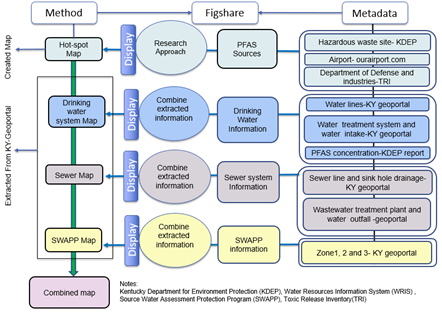
Dr. Ojha created the ArcGIS map for Kentucky with all the types of information required for PFAS stakeholders. The metadata information and overview of the procedure for creating a combined map are shown in the figure below.

Figure. A general overview of the procedures and data sources for creating water maps and a hot-spot map for PFAS. (Source: Ojha, S., Thompson, P. T., Powell, C. D., Moseley, H. N., & Pennell, K. G. (2022). A FAIR approach for detecting and sharing PFAS hot-spot areas and water systems.)
Please reach out to toXcel for more information on PFAS developments.
