
AI AND TECHNOLOGY
AI and Machine Learning
Transportation leaders need clear answers, faster crash-risk detection, smarter work-zones, fairer toll rates, yet the data keeps growing while budgets tighten. toXcel turns that complexity into confident action. We leverage emerging technologies like computer vision, natural-language processing, and predictive modeling to surface the right insight at the right moment, so agencies can intervene before small issues become system-wide problems.
Our support spans the full life-cycle of AI development.
We frame opportunities and ROI up front, engineer secure data pipelines, train and deploy models in cloud or on-prem environments, and keep everything evergreen with production-grade MLOps and intuitive dashboards. Built-in governance safeguards every step: bias testing, privacy and security controls, and transparent explanations thatwithstand public-sector audits. Along the way, we build capacity within your team, offering workshops, playbooks, and joint innovation sprints through the toXcel eXplore Labs, so the capabilities stay long after the project ends.
 toXcel developed AI models that accurately classified roadway surface type across 8+ states. These models were integrated into a GIS-based interface, allowing agencies to analyze routes using aerial imagery with over 90% accuracy.
 toXcel applied Large Language Models (LLMs) and unsupervised machine learning to crash reports as part of a Bicycle and Pedestrian Safety research effort. This work uncovered key trends in crash narratives and supported data-informed safety interventions for vulnerable road users.
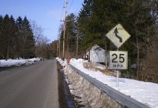 toXcel developed RoadVisionary, a proprietary computer vision platform that automates curve advisory speed calculations, sign inventories, and pavement marking retroreflectivity assessments. The platform transforms routine dashcam footage into actionable safety insights with minimal staff effort.
Analytics
Transportation programs generate massive amounts of data—from probe data to ITS sensor feeds to budget spreadsheets. toXcel’s analytics team converts those data into usable insights engineers can act on. We deliver performance dashboards that show congestion and reliability in real time, demand and revenue forecasts that support managed lanes pricing decisions, and automated safety scorecards that replace manual spreadsheets.
What we handle:
- Smart insights – deliver actionable intelligence on roadway and system performance, surfacing trends, anomalies, and predictive alerts so agencies always know where to focus.
- KPI definition & data audit – align metrics with program goals and document data gaps.
- Pipeline architecture – build secure warehouses and streaming ETL (Azure, Databricks, on-prem) with full tracking.
- Interactive reporting – deploy self-service visuals in Power BI, Tableau, or lightweight web apps so staff can drill from region to roadway in seconds.
- Quality & governance – embed validation rules, privacy controls, and traceability that stand up to public review.
- Capability transfer – provide targeted training, playbooks, and joint sprints in toXcel eXplore Labs so in-house teams can evolve the insights over time.
 To support the MarkSMART program at VDOT, toXcel built a dynamic cost-benefit tool and helped collect retroreflectivity data statewide. This allowed VDOT to evaluate the return on investment of mobile retroreflectometers and optimize striping schedules using predictive analytics.
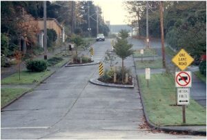
 toXcel assessed the effects of Yield-As-Stop laws by analyzing bicycle-motor vehicle conflict points across 57 counties and 20 cities. We used geospatial data to evaluate safety metrics and conducted a legislative review of jurisdictions implementing the “Idaho Stop.”
 toXcel supported the City of Bellevue, WA by integrating connected vehicle and cellular data into a decision-support dashboard. This tool helps city staff identify speed-related hotspots and evaluate the impact of countermeasures over time.
Technology
New sensors, connected-vehicle feeds, and AI-ready devices hit the market every month; agencies need a clear path from buzzword to benefit. toXcel guides that journey. We identify the right technologies, shape the business case, and stand up working prototypes that prove value before large-scale investment, so transportation leaders can modernize with confidence rather than guesswork.
What we handle:
- Technology scans & vendor benchmarking – systematic reviews of emerging hardware, data services, and software to compare capabilities, costs, and readiness.
- Business case & requirements – translate program goals into functional specs, ROI scenarios, and funding strategies.
- Prototype & pilot management – design test plans, coordinate vendors, and spin up cloud/GIS pipelines and dashboards to evaluate field performance.
- Custom applications & APIs – build lightweight decision-support tools and data services that connect new tech to existing systems without heavy re-platforming.
- Integration & knowledge transfer – align data standards, draft technical specs, and train agency staff so successful pilots scale smoothly.
The result is a risk-managed path from idea to implementation: agencies adopt only the technologies that demonstrate measurable safety and operational gains, and they retain full ownership of the knowledge and systems needed to keep advancing.
 For a High Water Monitoring Pilot, toXcel led a nationwide technology scan of flood detection systems and evaluated commercial offerings from 13 vendors. Based on this review, we recommended two systems for field testing, coordinated with vendors, and supported the design of automated alerts and roadway closures.
 toXcel conducted a comprehensive technology scan to evaluate technologies that reduce the illegal passing of school buses. We assessed the effectiveness, costs, and readiness of proposed and existing solutions and led a cost-benefit analysis to identify future research needs.
Innovation Advisory
Keeping pace with emerging trends is hard when budgets are tight and daily operations dominate attention. toXcel’s Innovation Advisory practice gives agencies a disciplined way to spot the right ideas, secure funding, and move from concept to field-proven solution without betting the farm. We combine strategic planning with hands-on coaching so new initiatives align with agency goals, hit ROI targets, and gain lasting support.
What we handle:
- Horizon scans & opportunity identification – benchmark emerging data, AI, and hardware trends; rank them against safety, operations, and budget priorities.
- Innovation roadmaps & prioritization – turn ideas into staged portfolios with clear objectives, timelines, and resource estimates.
- Pilot design & success metrics – define hypotheses, data-collection plans, and go/no-go thresholds to prove value quickly.
- Portfolio governance – implement stage-gate frameworks, ROI scorecards, and lightweight dashboards to track multiple pilots inparallel.
- Capability building – deliver workshops, playbooks, and co-development sprints in toXcel eXplore Labs so staff can run the nextround of innovation internally.
 As part of the Regional Multi-Modal Mobility Program (RM3P), toXcel provides technical guidance on the development and implementation of real-time commuter parking systems and an AI-based decision support platform. We provided vendor management, technical consulting, and performance monitoring for these innovative pilots.
 toXcel supported the development of the scoring methodology for the Innovation and Technology Transportation Fund (ITTF). Our work included designing an automated project ranking tool and creating a web application that allows districts to apply for funding and track submissions more efficiently.
eXplore Labs
eXplore Labs is our 10,000-square-foot proving ground where concepts move from whiteboard to roadway. The facility combines dedicated data-science studios with VR suites, a human-factors laboratory, and a full-service garage for sensor integration and vehicle instrumentation. Nearby, a rural road test track lets us test ideas in a controlled environment under real-world conditions, without waiting for a public-right-of-way permit.
What we make possible:
- Human-factors & driver-behavior research – Static and immersive VR labs, a mobile driving simulator for field deployments, and adrive-on simulator (under development) deliver repeatable studies on distraction, workload, and driver behavior.
- Rapid hardware & sensor prototyping – Garage space supports equipment and telemetry installs; on-site calibration means same-day testing.
- Closed-loop validation – Engineers can iterate software, hardware, and human-machine-interface changes in hours, not months—reducing risk before wider pilots.
 Whether refining an AI vision model, assessing driver reactions to new signage, or stress-testing a roadside sensor package, eXplore Labs gives agencies and industry partners a controlled, high-fidelity environment to prove performance and safety, then scale with confidence.
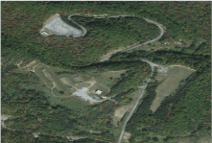 The Rural Roads Test Track, part of the eXplore Labs facility, allows real-world testing of curve advisory systems, sensor technologies, and automated data collection tools. This closed-course environment enables safe, repeatable trials prior to public deployment.
 toXcel’s Mobile Driving Simulator, developed through eXplore Labs, enables field-based driver behavior research. It supports controlled studies on distraction, workload, and reaction time in dynamic driving environments such as work zones and detours.